3D LiDAR Scanning for Real Estate & Utility Mapping, Gaithersburg
3D LiDAR Scanning for Real Estate & Utility Mapping, Gaithersburg
-
 Gaithersburg 20850, USA
 -
Posted: a week ago
-
 Save
Save -
 Share
Share
Description
Looking for LiDAR mapping solutions for your real estate project or utility infrastructure?
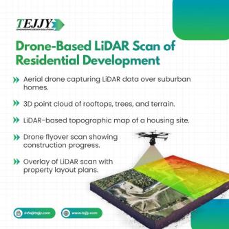
Our 3D LiDAR scanning services offer cutting-edge technology to capture accurate spatial data for buildings, terrain, and underground utilities. Whether you need detailed topographic maps for land development or reliable utility layouts for planning and compliance, LiDAR scanning ensures faster, safer, and more accurate results. Perfect for developers, surveyors, engineers, and utility companies.
Our Benefits:
High-Accuracy Data Collection
Improved Planning & Design
Enhanced Property Valuation
Efficient Utility Mapping
Faster Survey Turnaround
Reduced Field Risk
Comprehensive Documentation
Supports GIS & BIM Integration
Let’s map your next project with precision—contact our LiDAR team today for a quick consultation.
-
 Flag
Flag -
 Block ad
Safety Tips
Check what other local businesses charge for the same service.
Related searches
More info about this ad
3D LiDAR Scanning for Real Estate & Utility Mapping has been posted in the Gaithersburg Construction Services category on Locanto.
If you’re looking for something similar, check out Trusted MEP BIM Consultants in the USA | Reduce Rework And Time, Gaithersburg, Ensure Accuracy On-Site with Professional As-Built Plan Services, Gaithersburg or Advanced BIM Clash Solutions for Maryland Industrial Plants in 1 Research Ct, Ste 335, Rockville MD 20850, Gaithersburg, also posted in Construction Services. Right now, there are 32 classified ads in Construction Services in Gaithersburg on Locanto.
There are more ads within a 10 mi radius for this category. If you want to view those ads, click here.